
Save Minster Marshes

What Is Sea Link?
National Grid's Sea Link is a proposed 2GW high-voltage direct current (HVDC) electricity interconnector running under the North Sea between Kent and Suffolk. The project would bring cables ashore at Pegwell Bay — one of the most internationally protected stretches of coastline in the UK.
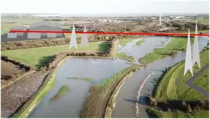
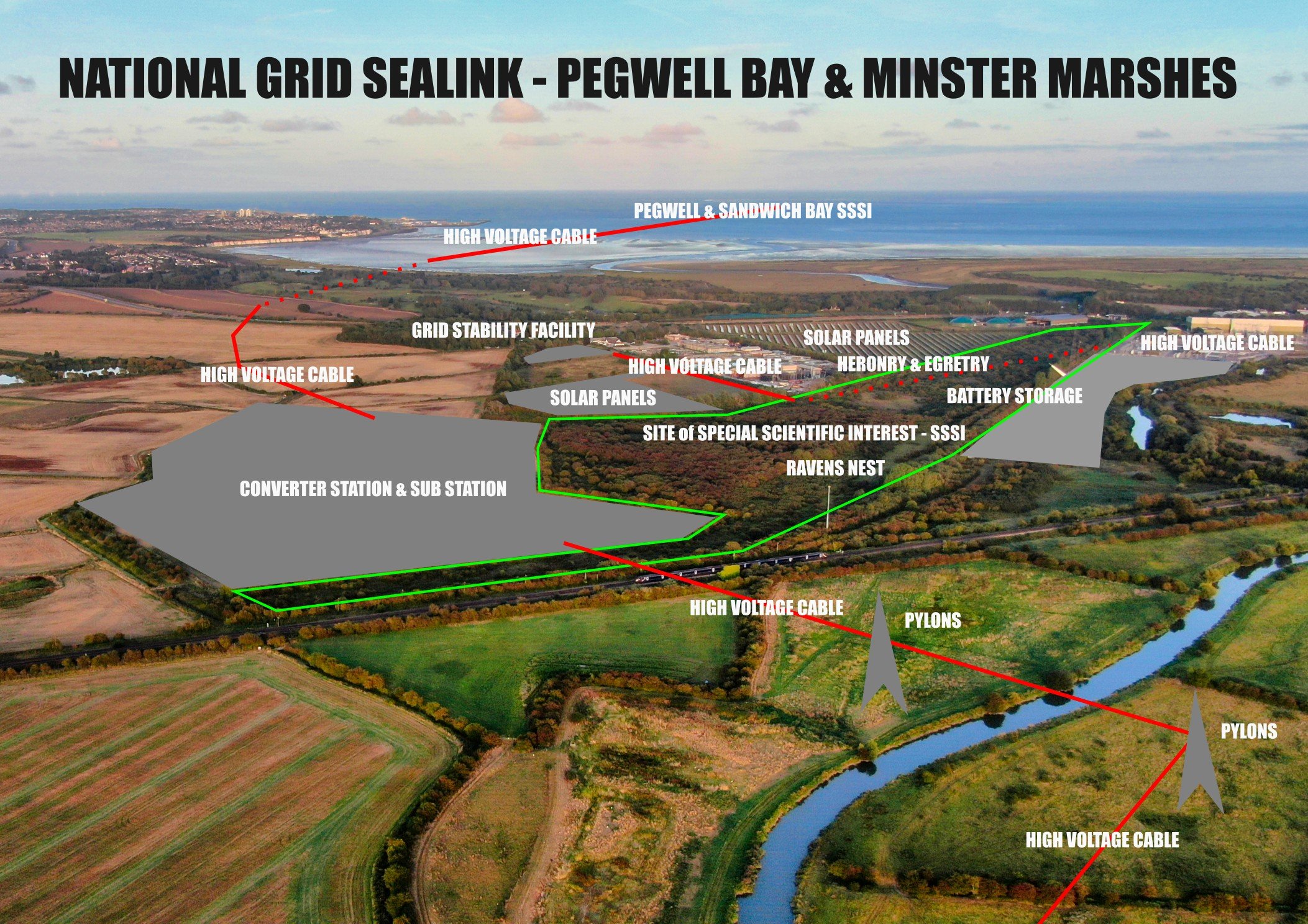
At the heart of the campaign's concerns is the proposed converter station on Minster Marshes — a 100ft tall building on a flooding marsh, requiring 40,000 lorry loads of aggregate, a 1km haul road with 27 water crossings, and deep foundation piles in a high water table environment.
The marshes sit adjacent to a Site of Special Scientific Interest (SSSI), support 37 red-listed species, and contain some of the most significant archaeology in Britain — including the likely landing site of St Augustine in 597AD and Caesar's marching camp.

Planning Timeline
The project required a Development Consent Order (DCO) — the planning process for nationally significant infrastructure. A year-long public examination has just concluded.
Examination Closed
Deadline 7 — the final written round — has now closed. All evidence, representations and submissions are in the hands of the independent Inspectors.
Inspector's Report
The Examining Authority will submit their recommendation report to the Secretary of State for Energy Security and Net Zero, covering all evidence heard.
Secretary of State Decision
The Secretary of State reviews the Inspectors' report and makes the final decision on whether to grant or refuse the Development Consent Order for the Sea Link project.
"An act of environmental vandalism."— Sir Roger Gale
Key Concerns
The proposed location raises serious issues across ecology, heritage, flood risk and community impact.
Habitat & Wildlife
37 red-listed species call these marshes home. The site borders a SSSI and hosts nationally rare farmland birds, wading birds, and invertebrates on land farmed since the 13th century.
Read more →
Pegwell Bay & Marine Life
The cable landfall at Pegwell Bay cuts through two Special Areas of Conservation, a Special Protection Area, a Ramsar site, and Kent's largest National Nature Reserve.
Read more →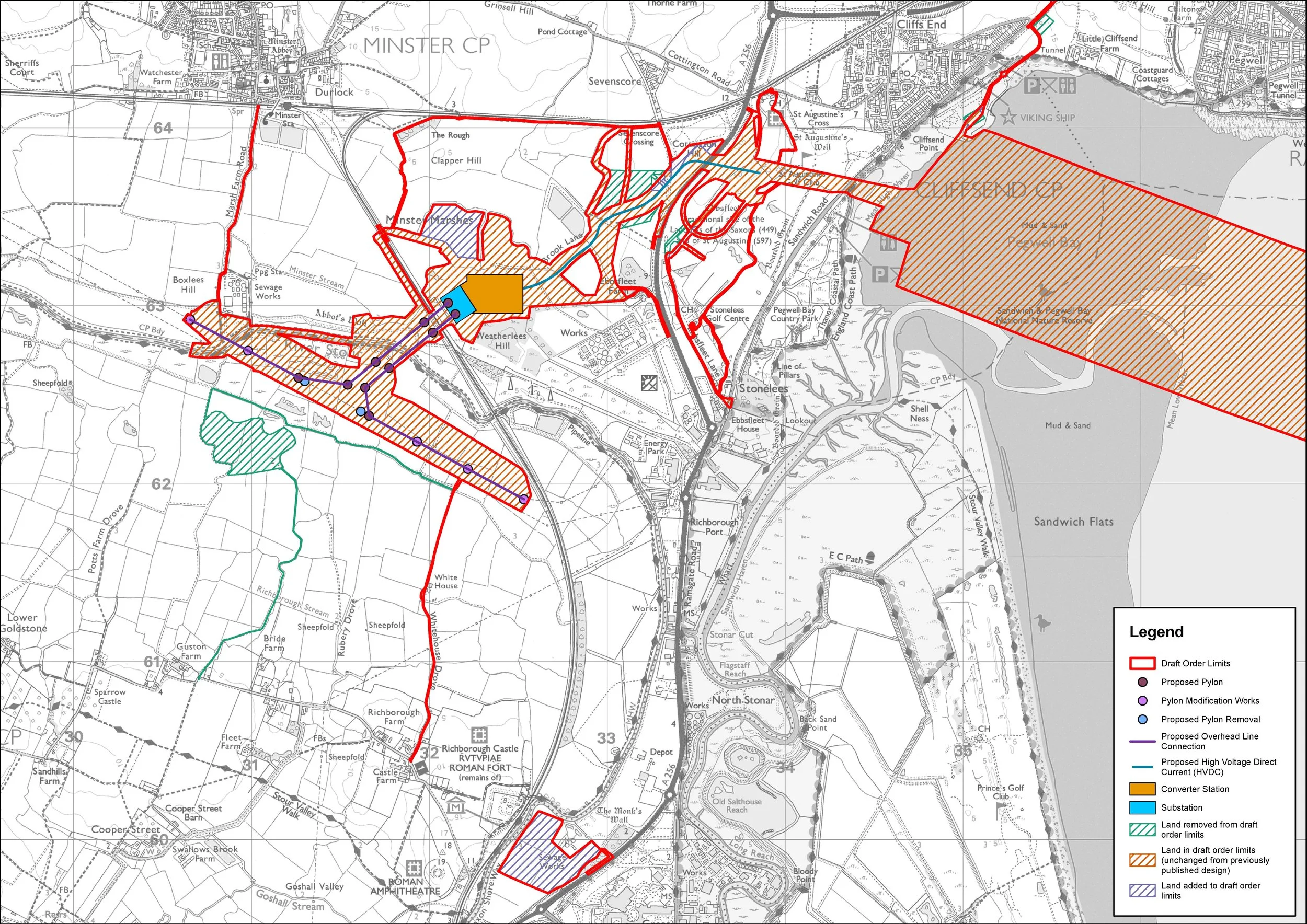
Flood Risk & Construction
The converter station sits on a marsh that floods. Stabilising it requires 40,000 lorry loads of aggregate, deep foundation piles, and a 1km haul road with 27 water crossings.
Read more →
Farmland & Agricultural Heritage
The proposed converter station, haul road and associated infrastructure would permanently take productive agricultural land out of use, compacted and severed by construction works across fields that have never been built upon. The deep piles and aggregate required to stabilise the building on this waterlogged ground could also contaminate the surrounding fresh water courses.
Read more →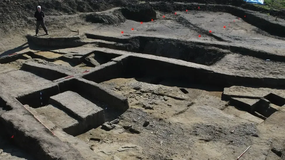
Archaeology & Heritage
The marshes are thought to contain Caesar's marching camp and the landing site of St Augustine (597AD). The haul road must now sit on top to protect what lies beneath.
Read more about archaeology →The Designations at Risk
Pegwell Bay — North East Kent Marine Protected Area
The cables make landfall at Pegwell Bay, one of the most heavily designated areas for nature conservation in the country. The North East Kent Marine Protected Area (NEKMPA) includes:
- Thanet Coast SAC & Sandwich Bay SAC (Special Areas of Conservation)
- Thanet Coast & Sandwich Bay SPA (Special Protection Area)
- Thanet Coast & Sandwich Bay Ramsar — Wetland of International Importance
- Thanet Coast SSSI (Site of Special Scientific Interest)
- Sandwich & Pegwell Bay National Nature Reserve — Kent's largest
- Thanet Coast Marine Conservation Zone
In 2003, 179 mute swans were killed by power lines in this corridor. The project proposes supersized pylons along the same flight path.
boundary map
Save Minster Marshes Merchandise

Show your support in the fight against destruction from National Grid's SeaLink project. We agree with the need for green energy but this should not be built at the expense of our environment.